The endless succession of wildly different landscapes is a constant in Italy, but when this contrast reaches its extremes, it still manages to surprise even those who were born and raised here. And in the heart of Marche — a green region that is, thankfully, still untouched by overtourism — hikers are met with a natural scene so surreal, almost Martian, that it recalls the rock formations of Utah or pockets of the Grand Canyon. Yet this landscape is the result of a uniquely Italian erosion process that has shaped it over millions of years. I had seen a few photos of the Lame Rosse and felt instantly drawn to them, eager to see with my own eyes how those pinkish walls and needle-shaped pinnacles could rise so sharply against a backdrop of lush green hills.
And then there’s Lake Fiastra — both the starting point of the trek and the well-deserved pause that follows — its water so green-blue it seems intent on stealing the spotlight. In a single day, you find yourself walking through a dazzling canyon before ending with your feet (and the rest of your body) in the cool water of an alpine reservoir, surrounded by endless forests. If you’re after a short hike with a definite wow-factor and a refreshing, relaxing finale, this is the trek for you.

Where are the Lame Rosse
The Lame Rosse are located in Marche, a central-eastern Italian region that’s often underestimated yet incredibly rich in places worth exploring. Marche is home to history-laden cities like Urbino and Fermo, hilltop villages, rolling landscapes dotted with vineyards and olive groves, and sandy beaches along the Adriatic coast. But it also hides — surprisingly for many — vast forests, mountains, and lakes waiting to be explored, with landscapes that rival those of its more famous neighbors, Umbria and Tuscany.
More specifically, the Lame Rosse sit within the Monti Sibillini National Park, just above Lake Fiastra in the province of Macerata. It’s a landscape that is both gentle and wild — one of Italy’s many hidden natural gems — offering endless possibilities for those who love walking and discovering unspoiled environments without having to tackle anything extreme.
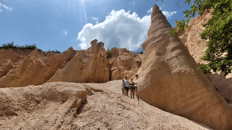
Lake Fiastra, on the other hand, is an artificial lake created by the dam built in the 1950s to harness the waters of the Fiastrone River for energy production. Yet the feeling you get as you approach the shoreline is entirely natural: transparent water, a backdrop of forests and mountains, and all around nothing but calm and quiet.
On the route I describe here, you can take your time: hike to the Lame Rosse along a trail that starts at the Lake Fiastra dam, return at your own pace, and then enjoy a relaxing afternoon at the lake’s equipped beach area, complete with a restaurant, bar, and pedal-boat rentals.
How to Get There
The easiest — and I would almost say the only practical — way to reach the starting point of this hike is by car. The trail begins at the Lake Fiastra dam, clearly marked on all maps and signposted along the road. It lies just north of the village of Fiastra, where you’ll also find the main swimming beach. Simply follow Provincial Road 91, which runs along the eastern side of the lake and leads directly to the dam. Free parking spaces near the trailhead are limited and tend to fill up quickly in summer, so arriving early is definitely a good idea.
Unfortunately, public transport is not a realistic option. The only possibility is to reach the nearby town of Camerino and take the local bus, which will get you to the hamlet of Fiegni in about an hour. From there, you’ll need to continue on foot to the start of the trail, adding another 45 minutes to your journey.
The Start of the Trail
The trail to the Lame Rosse begins right at the dam, marked by the CAI sign — the Club Alpino Italiano, the national association that provides official information for hikers across the country. The first stretch simply follows the dam across the lake before the ascent begins. The starting altitude is around 620 meters, while the Lame Rosse sit at roughly 860 meters above sea level, making the elevation gain modest and the hike pleasantly short.
The trail you’ll follow is CAI 335, clearly marked with the classic red–white–red stripes painted on rocks along the way. The path is well-trodden, and it’s virtually impossible to take a wrong turn.
The first part of the climb is gentle: a wide gravel road with small stones, entirely manageable, and already rewarding after just a few minutes with beautiful views over the lake — especially on bright, sunny days, when the water shows off its stunning color.
The second section leads into a lovely holm oak forest. You’ll be in the shade, which is a real treat in summer, and every now and then the lake peeks through the trees below.
After about 45 minutes, everything changes at once: the vegetation opens up, and you suddenly find yourself at the start of the third and final section — the most demanding one — a slope of loose scree that climbs steeply and unevenly toward the canyon.
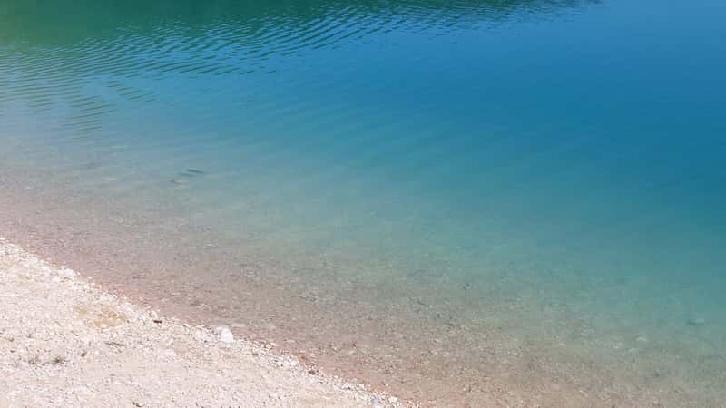
The scenery turns dazzling: the green of the forest gives way entirely to pale, sunlit gravel. The scree is flanked by woodland, but the center of the path is completely exposed, covered in light-colored pebbles that make the ascent more challenging. Only after 10–15 fairly tough minutes do you reach the pinnacles of the Lame Rosse — and needless to say, the effort is absolutely worth it.
These formations, named after their elongated, blade-like shapes (lama means blade in Italian, and rosse means red), reach up to 20 meters in height and display shades of pink, orange, and red thanks to the iron-rich clay and silt that compose them. Sculpted by wind erosion over thousands of years, their limestone base feeds the scree slope below. Today, they rise with their bizarre, almost whimsical shapes, as if placed there by an eccentric architect determined to surprise anyone who makes the effort to reach them.
The first emotion you feel is pure astonishment — who would expect something halfway between Cappadocia and an American canyon in the green heart of Italy?
My advice is not to stop at the first cluster of formations. It’s tempting to think you’ve arrived as soon as you reach the initial rock walls at the top of the scree, but it’s far more rewarding to continue all the way up. There, you’ll likely find fewer people — perhaps no one at all — and you’ll stand right beneath the tallest, most vividly colored pinnacles.
Once you’re up there, the vegetation just below the highest formations offers welcome shade, perfect for a well-earned break (or a picnic, like the one I enjoyed).
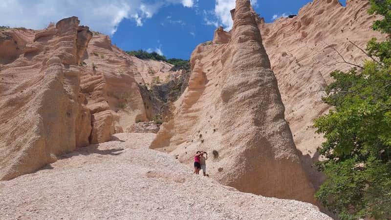
The rock formations themselves are also surprisingly fun to explore. You can walk along their base and slip into the small gaps and recesses that open between them. But you’ll need to resist the temptation to climb them: these structures are extremely fragile, easily damaged, and potentially dangerous to climb. Preserving them is part of preserving the magic of this place.
How Difficult Is the Hike
A moderately fit hiker will enjoy this trail from start to finish: as mentioned, it’s simple, short, and absolutely manageable. In just over two hours you can reach the Lame Rosse and return to the dam. There are only two things to keep in mind: there is no water along the route (so on hot days bringing a full bottle is essential), and there is no mobile coverage for most of the hike, making communication or calling for help impossible if needed. You will need hiking shoes or boots.
Here’s a quick recap of the trail’s key features:
- Difficulty: Moderate
- Total hiking time (round trip): about 2 hours
- Elevation gain: 270–300 m, considering ups and downs
- Total distance: roughly 7 km
- Terrain: forest path + final scree slope
- Suitable for children? Yes, if they are used to walking
- Suitable for dogs? Yes, but take care on the loose gravel sections
Safety and a Few Practical Tips
- The Lame Rosse are not a playground: the pinnacles are fragile, and climbing them is prohibited and unsafe.
- In summer, the final scree slope gets extremely hot: those 10–15 minutes can feel intense under the blazing sun, and the bright light reflected by the gravel can be blinding.
- Bring plenty of water: there are no fountains or refill points along the route.
- Wear hiking boots (no flats)
- Wind can lift dust and fine gravel, especially near the canyon.
When to Go
Because of the heat — the number one enemy of this hike — the best times to visit are from April to June and from September to October. The colors will be stunning, and the weather ideal for walking.
Winter is not recommended: the terrain can become slippery, and frost and rain can make the ascent unpleasant and unsafe.
July and August are definitely hotter and more strenuous on the final slope, but they do reward you with the perfect ending to your Lame Rosse trek: a refreshing dip in Lake Fiastra.
Swimming in Lake Fiastra
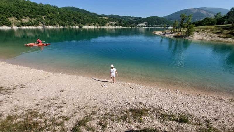
After the red dust of the trail and a two-hour walk, dipping your feet — or your whole body — into the lake feels incredible. The equipped beach in the village of Fiastra, about 3 km south of the trailhead, gives the impression of arriving at a fully fledged seaside resort without the usual crowds. The water is crystal clear, the bar offers snacks, ice creams, and coffee, and pedal-boat rentals let you explore the lake from a completely different angle.
In this part of the region, July and August often reach 35°C, making Lake Fiastra the perfect place to unwind for a few hours — or even a few days — in total relaxation.
Where to Eat and Stay
Besides the restaurant on the lakefront, Fiastra has a handful of small restaurants and bars offering honest, down-to-earth service at very reasonable prices. The food, however, is sensational: platters of local products, mushroom dishes, traditional Marche pasta, and hearty mountain fare — exactly what you need to fully recover after the hike.
Why This Trek Stays with You
It’s not just the beauty — it’s the contrast. You walk through a forest, step into a valley that looks like a Star Wars set, then descend again and find yourself sitting by an emerald-green lake. All of this in just under three hours. And at the same time, it’s an experience that remains totally accessible.